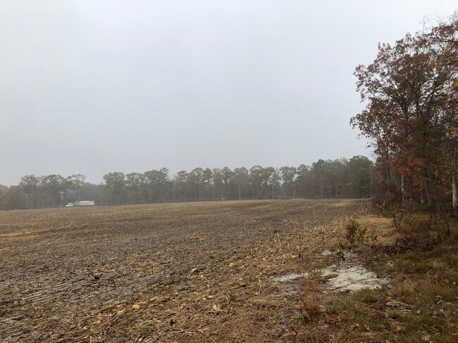
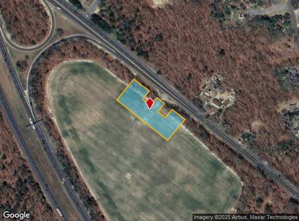
Property Record
Harding Hwy, Franklin, NJ 07416
NEARBY LISTINGS FOR SALE OR LEASE
Property Detail
Harding Hwy
Philadelphia-Camden-Wilmington, PA-NJ-DE-MD
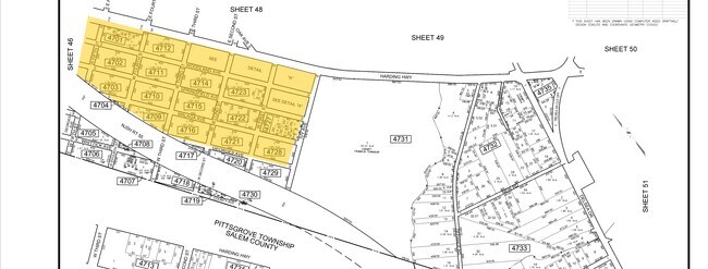
ADDITIONAL LOTS: :4702,1:4703,1
05-04701-0000-00001-0000-QFARM
Gloucester
Farms
New Jersey
X
1
34011C0054E
4.96 AC
2024
Gloucester County
2025
Philadelphia
372900
DEMOGRAPHICS near Harding Hwy
1 Mile
3 Mile
5 Mile
2024 Total Population
919
9,716
24,331
2029 Population
935
9,887
24,727
Pop Growth 2024-2029
+ 1.74%
+ 1.76%
+ 1.63%
Average Age
42
42
42
2024 Total Households
344
3,635
9,044
HH Growth 2024-2029
+ 2.03%
+ 1.73%
+ 1.57%
Median Household Inc
$74,181
$73,542
$79,805
Avg Household Size
2.70
2.60
2.70
2024 Avg HH Vehicles
2.00
2.00
2.00
Median Home Value
$225,000
$230,136
$234,513
Median Year Built
1981
1974
1976
Nearby Places
Map Layers
Map Styles
 Street
 Aerial
- Restaurants
- Banks
- Shops
- Fitness
- Groceries
PUBLIC TRANSPORTATION
AIRPORT
Atlantic City International
DRIVE
WALK
Distance
Atlantic City International
68 min
33.1 mi
Philadelphia International
DRIVE
WALK
Distance
Philadelphia International
50 min
35.1 mi
Freight Ports
Broadway Terminal - Pier 5
DRIVE
WALK
Distance
Broadway Terminal - Pier 5
34 min
26.6 mi
SALE & LEASE HISTORY
LISTING DATE
SALE/LEASE

Jun 14, 2017
For Sale
Feb 16, 2022
For Sale
Feb 02, 2017
For Sale
Nearby Properties
Address
Land Use
TOTAL SIZE
Lot Size
Zoning
Address
Land Use
TOTAL SIZE
Lot Size
Zoning
84.63 AC
RA
Address
Land Use
TOTAL SIZE
Lot Size
Zoning
Address
Land Use
TOTAL SIZE
Lot Size
Zoning
15.12 AC
I1
Address
Land Use
TOTAL SIZE
Lot Size
Zoning
8.65 AC
Address
Land Use
TOTAL SIZE
Lot Size
Zoning
8.96 AC
I1
Address
Land Use
TOTAL SIZE
Lot Size
Zoning
17.10 AC
RA
Address
Land Use
TOTAL SIZE
Lot Size
Zoning
3.11 AC
FV
Address
Land Use
TOTAL SIZE
Lot Size
Zoning
1,358 SF
9.10 AC
RA
Address
Land Use
TOTAL SIZE
Lot Size
Zoning
663.70 AC
Address
Land Use
TOTAL SIZE
Lot Size
Zoning
Address
Land Use
TOTAL SIZE
Lot Size
Zoning
5.61 AC
I1
Address
Land Use
TOTAL SIZE
Lot Size
Zoning
Address
Land Use
TOTAL SIZE
Lot Size
Zoning
1.52 AC
MV
Address
Land Use
TOTAL SIZE
Lot Size
Zoning
5.02 AC
I1
Address
Land Use
TOTAL SIZE
Lot Size
Zoning
4,732 SF
3.04 AC
FV
Address
Land Use
TOTAL SIZE
Lot Size
Zoning
32,451 SF
11 AC
Address
Land Use
TOTAL SIZE
Lot Size
Zoning
19,902 SF
27.16 AC
I1
Address
Land Use
TOTAL SIZE
Lot Size
Zoning
1,344 SF
49.22 AC
LM
Address
Land Use
TOTAL SIZE
Lot Size
Zoning
5.05 AC
I1
Address
Land Use
TOTAL SIZE
Lot Size
Zoning
275.24 AC
RA
Address
Land Use
TOTAL SIZE
Lot Size
Zoning
13.20 AC
A
Address
Land Use
TOTAL SIZE
Lot Size
Zoning
Address
Land Use
TOTAL SIZE
Lot Size
Zoning
9.53 AC
HC
Address
Land Use
TOTAL SIZE
Lot Size
Zoning
5.47 AC
I1
Address
Land Use
TOTAL SIZE
Lot Size
Zoning
2.89 AC
I1
Address
Land Use
TOTAL SIZE
Lot Size
Zoning
1.52 AC
HC
Address
Land Use
TOTAL SIZE
Lot Size
Zoning
1,590 SF
1.89 AC
HC
Address
Land Use
TOTAL SIZE
Lot Size
Zoning
9,160 SF
2 AC
FV
Address
Land Use
TOTAL SIZE
Lot Size
Zoning
6.64 AC
I1
Address
Land Use
TOTAL SIZE
Lot Size
Zoning
267.75 AC
The World's #1 Commercial Real Estate Marketplace
Connect with us
© 2025 CoStar Group
The information above has been obtained from sources believed reliable. While we do not doubt its accuracy we have not verified it and make no guarantee, warranty or representation about it. It is your responsibility to independently confirm its accuracy and completeness. Any projections, opinions, assumptions, or estimates used are for example only and do not represent the current or future performance of the property. The value of this transaction to you depends on tax and other factors which should be evaluated by your tax, financial, and legal advisors. You and your advisors should conduct a careful, independent investigation of the property to determine to your satisfaction the suitability of the property for your needs.